
Central Canada: Severe Thunderstorms & Large Hail Risk
A classic late-May collision between a sticky, summer-like air mass and a sharp cold front will fire thunderstorms across central Canada this week. The storms are forecast to bring large hail along with damaging winds and torrential downpours. In my emergency department, we know what’s coming. Days like these fill waiting rooms.
Heat and instability set the stage
Over the next 48 hours, a ridge of high pressure over the Prairies will shove hot, humid air into northwestern Ontario. Temperatures climb into the mid-to-upper 20s, sweaty weather that sends people outside, often unprepared. Even before the storms, the heat itself triggers dehydration and heat exhaustion cases. Meanwhile, a low-pressure system tracking east from the plains slices into that warm soup. The clash produces violent, rotating storms. Forecasters expect the first severe cells to pop Monday afternoon near Sandy Lake and Fort Hope, then slide toward Thunder Bay as the cold front catches up. By Tuesday, the storm engine shifts to central Quebec, focusing on Lac-Saint-Jean and Saguenay, where broken squall lines may bring strong wind gusts and a small tornado risk from high wind shear.
When hail becomes a health hazard
Hail sounds dramatic in a car commercial but does swift damage to the human body. Large hailstones fall at over 100 km/h. They can fracture a skull, cause a concussion, or—more commonly—leave lacerations and deep bruises. Children, the elderly, and people on blood thinners are extra vulnerable. Even a stone no bigger than a golf ball can split an earlobe or crush a finger. We see hand fractures every season from people who tried to fend off hail with a garbage bin lid. If you hear a roar on the roof that sounds louder than hard rain, or see a white curtain approaching across a field, get indoors immediately. Don’t try to rescue lawn ornaments or cover patio furniture.
Lightning: the “bolt from the blue” problem
I hear it all the time after a storm passes: “I was walking to my car, it wasn’t even raining.” Lightning can strike up to 16 kilometres from the parent storm, in what meteorologists call a bolt from the blue. In the flat stretches of northwestern Ontario and the farm corridors of southern Quebec, that distance can be deceptive. A dark smudge on the horizon still has an electric field that can discharge in less than a second. I’ve seen patients with burns, temporary paralysis, and cardiac irregularities after near misses. The 30-30 rule works. Count the seconds between flash and thunder; under 30, take cover. Stay indoors for 30 minutes after the last clap. Rubber-soled shoes won’t help. Inside a car, you’re safe only if you avoid touching metal components. The safest place is a fully enclosed building, away from windows and plumbing.
Toronto’s fast-moving front
Toronto starts mild and sunny this morning, deceptively calm. By early afternoon, a fast-moving front rolls through, triggering thunderstorms with wind gusts up to 36 km/h. That won’t knock you over, but combine gusting wind with a sudden torrent of rain, and construction hoardings can tip, patio umbrellas sail away. For cyclists and pedestrians along the waterfront or the Gardiner, conditions flip treacherous in under ten minutes. The ER braces for a spike in minor trauma: twisted ankles on wet stairs, broken bones from falling objects. Car crashes jump as drivers hydroplane on a downburst. The front clears fast, often by evening, and that rapid improvement lulls people into a false sense of security. Don’t assume the storm is over until radar says it’s over.
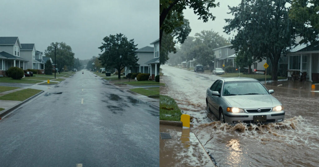
Flash floods and a temperature crash
The cold front brings a hidden risk: a temperature plunge of more than 20 degrees Celsius overnight. Barrie could go from 28°C Tuesday afternoon to 6°C by Wednesday morning; London from near 30°C to roughly 7°C. That’s a shock. Elderly patients who go to bed with the window open on a warm evening sometimes wake up hypothermic. Flash flooding during the storms is more immediate. Repeated heavy downpours in low-lying areas around the 401 corridor and the GTA can flood underpasses and basements fast. Just 15 cm of moving water sweeps a person off their feet. If you’re driving and encounter a flooded street, turn around. Water hides sinkholes and runs deeper than it looks. Near-drowning injuries from wading into what seemed like a shallow puddle are not rare in the aftermath.
Practical preparedness
A few steps cut the risk sharply. Download a weather alert app with push notifications—Environment Canada watches and warnings are your early warning system. When a severe thunderstorm watch gets upgraded to a warning, act. Keep a small go bag with essential medications, a first-aid kit, a flashlight, and bottled water. Not just for tornadoes; it helps if you need to move fast or lose power. Designate a safe room: a basement or interior windowless room on the lowest floor, away from windows, electrical appliances, and plumbing. Hail and wind-borne debris shatter glass in an instant. During a storm, stay put. Don’t go outside for a dramatic photo. Check on elderly neighbours before the storm and after the rapid cooldown. After the storm, watch for downed power lines that may be live and standing water that could be contaminated. If you smell gas, leave and call 911.
By Wednesday morning, thermometers in Barrie and London will hover near 6°C. Many windows will still be open, letting in the chill that followed the heat.
*Disclaimer: This article is for informational purposes only and does not replace professional medical advice. If you or someone you know is injured or has a medical emergency, please call 911 or your local emergency number immediately.*